Darb al-Labbana neighbourhood, Historic Cairo — site condition before conservation works, with mosque minarets visible in the distance
Islamic Heritage
2025

urban conservation & rehabilitation

Location

Historic Cairo, Egypt

Period

2019 – 2025

Role

General Consultant & Project Director

Client

Urban Development Fund / Engineering Authority of the Armed Forces

Project Description

A groundbreaking 10-feddan (42,500 m²) urban conservation masterplan for one of Historic Cairo's most endangered medieval neighbourhoods, part of the UNESCO World Heritage site. The project introduced an internationally unprecedented methodology: dismantling structurally unsafe historic stone façades stone by stone, rebuilding safe structural cores, then re-mounting the original stones in exact original sequence — preserving authenticity while ensuring habitability.

Darb al-Labbana lies between Bab al-Wazir and the foot of the Citadel — a 10-feddan (42,500 m²) fragment of medieval Cairo carrying nine listed Islamic monuments from the 11th to 19th centuries and 131 land parcels that had quietly decayed for decades. The project, commissioned by the Urban Development Fund and the Engineering Authority of the Armed Forces and submitted in the Tanseeq Competition (2020–2022), reframed urban conservation in Egypt: it treats the historic fabric not as scenery to be saved, but as a living district whose families, crafts, and stones must move forward together.

Key Achievements

  • 131 land parcels documented via full GIS survey
  • 9 Islamic monuments from the 11th–19th centuries inside the project boundary
  • 52 of 97 original families returned to their restored homes
  • Discovery of two medieval cisterns mid-construction, preserved as heritage display
  • First Phase completion 2025 — now a national model for Historic Cairo districts

The defining methodological move is structural rather than cosmetic. Where façades are unsafe but historically authentic, the team dismantles the original stones one by one, indexes each piece, rebuilds a safe modern structural core inside, and remounts the original stones in their exact original sequence. Authenticity is preserved at the level of the individual stone; habitability is delivered by a contemporary engineered backbone. The approach is bound to an unprecedented socio-spatial survey: GIS documentation of all 131 parcels, parcel-level façade and plan drawings for 1990 / 2021 / 2023, family-by-family return tracking, and an inventory of crafts and economic activity that must continue inside the conservation zone.

Six phases that turned an endangered medieval district into a living, documented, returnable home.

01

survey & documentation

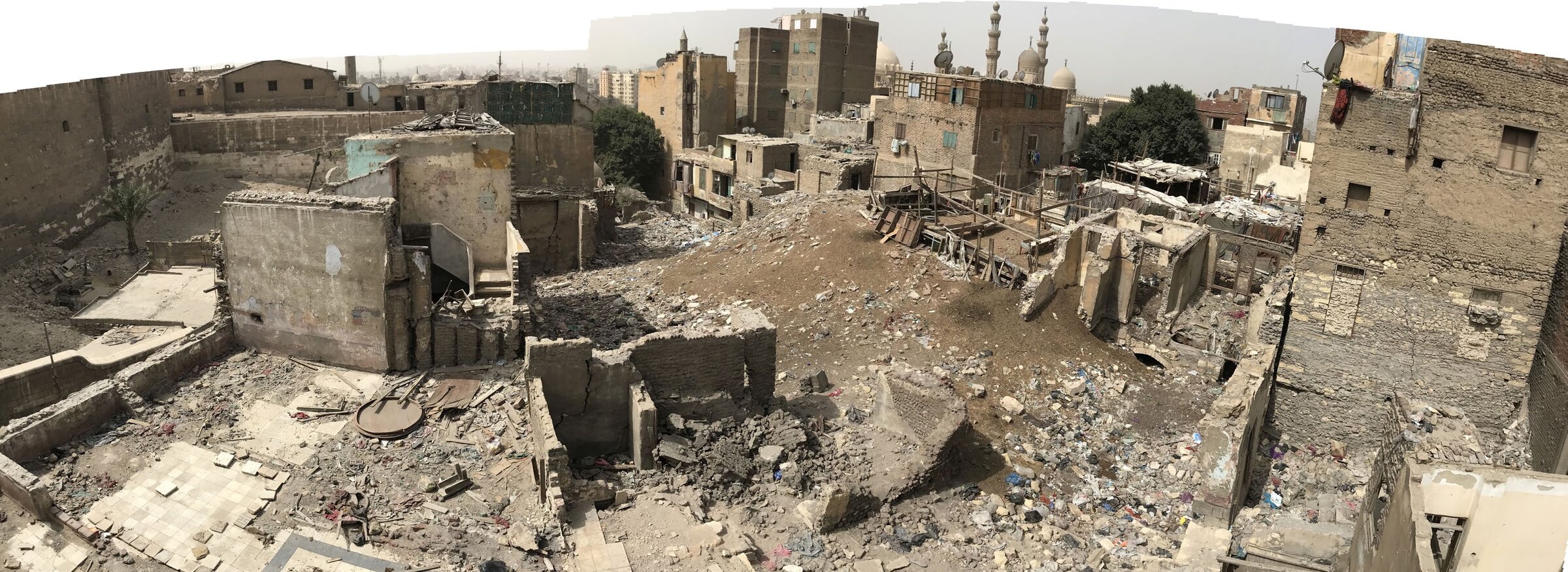
Every one of the 131 parcels was recorded — façade elevations, plan layouts, structural condition, ownership status, and the families occupying each unit. Historical photographs from the early 20th century onward were correlated with present-day fabric to identify what is original, what is replaced, and what is lost. Three temporal cross-sections were drawn: 1990, 2021, and 2023.

02

gis & urban analysis

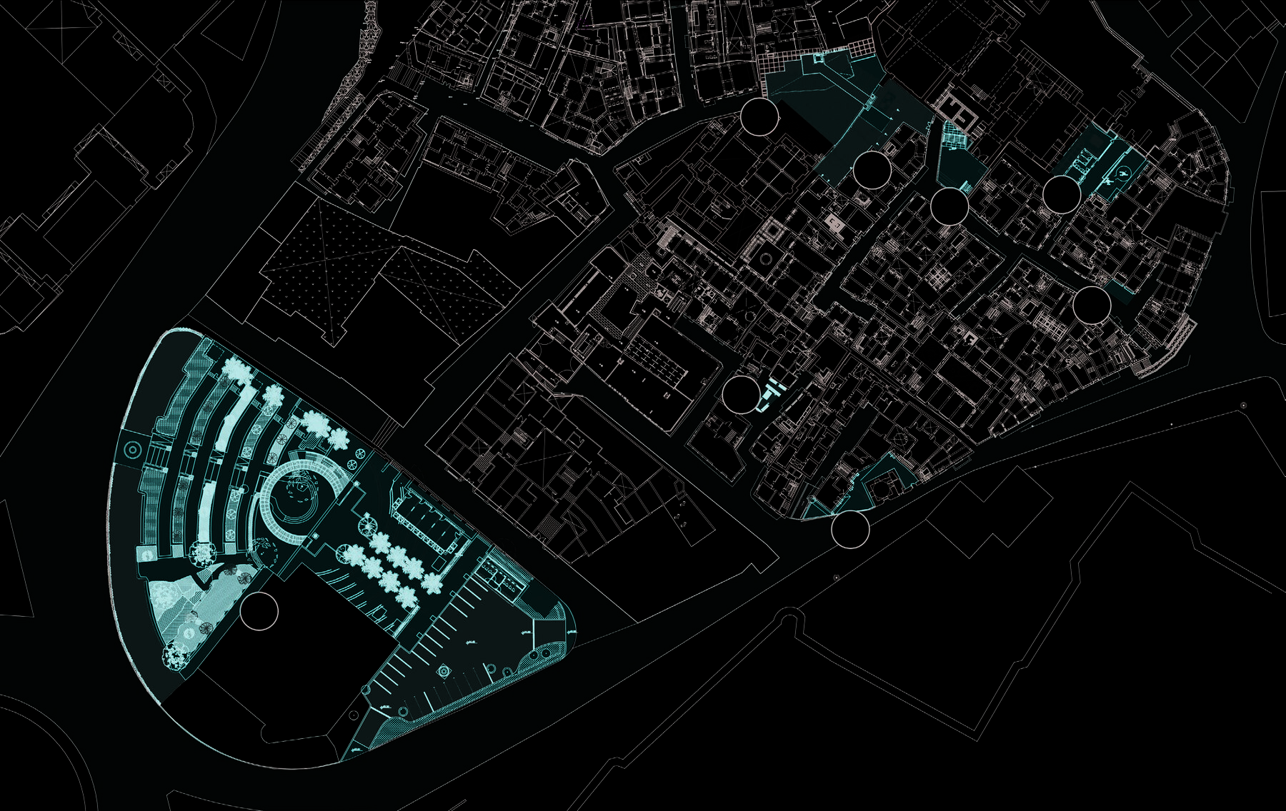
The team produced layered Geographic Information System maps of the district from 2020 to 2022 — recording use, height, structural integrity, monumental status, and economic activity. Nine officially listed monuments from the 11th to 19th centuries were mapped against the wider tissue of vernacular housing, mosques, sabils, and crafts workshops.

03

community integration

Conservation in Cairo has too often meant displacement. Here, the methodology required the opposite: 52 of 97 original families were returned to their restored homes after a parcel-by-parcel relocation and re-housing programme. Existing crafts, retail, and services were inventoried and given a place in the new plan, not edited out of it.

04

structural dismantling & re-mounting

For parcels where the façades were unsafe but historically valuable, each stone was numbered, removed, and stored. A new structural core was built behind to current safety standards. The original stones were then remounted in exact original sequence — preserving the authentic façade while delivering a habitable interior. Mid-construction, two medieval cisterns were discovered and preserved in situ as a heritage display.

05

plazas & public realm

Areas of cleared rubble and irrecoverable structures were reorganised into new public plazas, calibrated against the surviving fabric. Surfaces, levels, vegetation, and street furniture were drawn to support the everyday life of returning residents while opening clear sight-lines onto the listed monuments.

06

phase i delivery

First Phase completion in 2025 produced both a finished neighbourhood and a transferable methodology. Darb al-Labbana is now cited as a national model for how UNESCO-listed districts in Cairo can be conserved without erasing the people who carry their meaning.

Master plans, documentation, and construction phases — browsed in two reels.

Drawings & Documents
01 / 04
Master plan of Darb al-Labbana — circulation, intervention zones, and the new public plaza shown over the medieval fabric of Historic Cairo

Master plan — circulation, intervention zones, and the new public plaza set into the medieval fabric.

Construction & Delivery
01 / 03
Placeholder — re-mounting of historic façade stones onto new core, coming soon

Re-mounting — original stones returned to their exact sequence over a new engineered core.

Next Project

bab zuwayla

View →